![](/images/other/stat-length.png)
![Excursión Senderismo Woluwe-Saint-Lambert - Sint-Lambrechts-Woluwe - 3km-ADEPS-Singelijn-31032024 - Photo](https://media.geolcdn.com/t/1900/400/ext.pjpeg?maxdim=2&url=https%3A%2F%2Fstatic1.geolcdn.com%2Fsiteimages%2Fupload%2Ffiles%2F1553511878bg_sport_marche.png)
3km-ADEPS-Singelijn-31032024
oesibius
Usuario
![Longitud](/images/other/stat-length.png)
Longitud
2,9 km
![Altitud máxima](https://static1.geolcdn.com/siteimages/upload/files/1508320355ic_sort_altitude_max_24dp.png)
Altitud máxima
63 m
![Desnivel positivo](https://static1.geolcdn.com/siteimages/upload/files/1508320355ic_sort_den_pos_24dp.png)
Desnivel positivo
28 m
![Km-Effort](/images/other/stat-length.png)
Km-Effort
3,3 km
![Altitud mínima](https://static1.geolcdn.com/siteimages/upload/files/1508320355ic_sort_altitude_min_24dp.png)
Altitud mínima
40 m
![Desnivel negativo](https://static1.geolcdn.com/siteimages/upload/files/1508320355ic_sort_den_neg_24dp.png)
Desnivel negativo
26 m
![Boucle](https://static1.geolcdn.com/siteimages/upload/files/16400158638029165_repeat_loop_refresh_sync_direction_icon.png)
Boucle
Sí
Fecha de creación :
2024-03-27 09:59:12.181
Última modificación :
2024-03-27 10:04:09.362
![Senderismo](https://static1.geolcdn.com/sitytour/trail-icons/101.png)
44m
Dificultad : Fácil
![Escanee este código QR para abrir la excursión en la aplicación SityTrail](https://capi.geolives.com/qq0zvz2zws4bq2lad0pu/sitytour/trails/3995345/qr.png?size=200)
Aplicación GPS de excursión GRATIS
A propósito
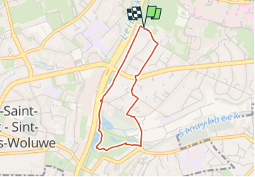
Ruta Senderismo de 2,9 km a descubrir en Région de Bruxelles-Capitale - Brussels Hoofdstedelijk Gewest, Desconocido, Woluwe-Saint-Lambert - Sint-Lambrechts-Woluwe. Esta ruta ha sido propuesta por oesibius.
Descripción
Parcours de 3km pour la marche ADEPS du 31/3/2024, organisé par l'école Singelijn
Localización
País:
Belgium
Región :
Région de Bruxelles-Capitale - Brussels Hoofdstedelijk Gewest
Departamento/provincia :
Desconocido
Municipio :
Woluwe-Saint-Lambert - Sint-Lambrechts-Woluwe
Localidad:
Unknown
Salida:(Dec)
Salida:(UTM)
601640 ; 5634204 (31U) N.
Comentarios
Excursiones cerca
![Excursión Senderismo Auderghem - Oudergem - RB-BXL-10-Rac02 - Photo](https://media.geolcdn.com/t/375/260/ext.jpg?maxdim=2&url=https%3A%2F%2Fservices.sitytrail.com%2FGeolivesWS%2FDownloadMedia.ashx%3FTrailID%3D247907%26Media%3Db30f5581-2af5-47b0-aca2-8f9cddfbea28.jpg)
![Senderismo Senderismo](https://static1.geolcdn.com/sitytour/trail-icons/101.png)
RB-BXL-10-Rac02
Senderismo
Fácil
(10)
Auderghem - Oudergem,
Région de Bruxelles-Capitale - Brussels Hoofdstedelijk Gewest,
Desconocido,
Belgium
![](/images/other/stat-length.png)
13,6 km | 16,2 km-effort
3h 40min
![](https://static1.geolcdn.com/siteimages/upload/files/16400158638029165_repeat_loop_refresh_sync_direction_icon.png)
Sí
![Excursión Senderismo Auderghem - Oudergem - RB-Br-09 Raccourci 2 - Photo](https://media.geolcdn.com/t/375/260/ext.jpg?maxdim=2&url=https%3A%2F%2Fservices.sitytrail.com%2FGeolivesWS%2FDownloadMedia.ashx%3FTrailID%3D247903%26Media%3D4f2f6ef8-5647-4df5-b72e-d8a55c5e5b6f.jpg)
![Senderismo Senderismo](https://static1.geolcdn.com/sitytour/trail-icons/101.png)
RB-Br-09 Raccourci 2
Senderismo
Fácil
(9)
Auderghem - Oudergem,
Région de Bruxelles-Capitale - Brussels Hoofdstedelijk Gewest,
Desconocido,
Belgium
![](/images/other/stat-length.png)
15,3 km | 18 km-effort
4h 5min
![](https://static1.geolcdn.com/siteimages/upload/files/16400158638029165_repeat_loop_refresh_sync_direction_icon.png)
Sí
![Excursión Senderismo Auderghem - Oudergem - RB-Br-09 - Photo](https://media.geolcdn.com/t/375/260/ext.jpg?maxdim=2&url=https%3A%2F%2Fservices.sitytrail.com%2FGeolivesWS%2FDownloadMedia.ashx%3FTrailID%3D247899%26Media%3D7b6d3a4f-3999-4d35-8f7d-f23163489b77.jpg)
![Senderismo Senderismo](https://static1.geolcdn.com/sitytour/trail-icons/101.png)
RB-Br-09
Senderismo
Medio
(8)
Auderghem - Oudergem,
Région de Bruxelles-Capitale - Brussels Hoofdstedelijk Gewest,
Desconocido,
Belgium
![](/images/other/stat-length.png)
20 km | 25 km-effort
5h 34min
![](https://static1.geolcdn.com/siteimages/upload/files/16400158638029165_repeat_loop_refresh_sync_direction_icon.png)
Sí
![Excursión Senderismo Auderghem - Oudergem - RB-BXL-10 - Photo](https://media.geolcdn.com/t/375/260/ext.jpg?maxdim=2&url=https%3A%2F%2Fservices.sitytrail.com%2FGeolivesWS%2FDownloadMedia.ashx%3FTrailID%3D247904%26Media%3Db30f5581-2af5-47b0-aca2-8f9cddfbea28.jpg)
![Senderismo Senderismo](https://static1.geolcdn.com/sitytour/trail-icons/101.png)
RB-BXL-10
Senderismo
Medio
(4)
Auderghem - Oudergem,
Région de Bruxelles-Capitale - Brussels Hoofdstedelijk Gewest,
Desconocido,
Belgium
![](/images/other/stat-length.png)
21 km | 25 km-effort
5h 38min
![](https://static1.geolcdn.com/siteimages/upload/files/16400158638029165_repeat_loop_refresh_sync_direction_icon.png)
Sí
![Excursión Senderismo Auderghem - Oudergem - RB-Br-09 Raccourci 1 - Photo](https://media.geolcdn.com/t/375/260/ext.jpg?maxdim=2&url=https%3A%2F%2Fservices.sitytrail.com%2FGeolivesWS%2FDownloadMedia.ashx%3FTrailID%3D247901%26Media%3D4f2f6ef8-5647-4df5-b72e-d8a55c5e5b6f.jpg)
![Senderismo Senderismo](https://static1.geolcdn.com/sitytour/trail-icons/101.png)
RB-Br-09 Raccourci 1
Senderismo
Fácil
(4)
Auderghem - Oudergem,
Région de Bruxelles-Capitale - Brussels Hoofdstedelijk Gewest,
Desconocido,
Belgium
![](/images/other/stat-length.png)
16 km | 19,1 km-effort
4h 20min
![](https://static1.geolcdn.com/siteimages/upload/files/16400158638029165_repeat_loop_refresh_sync_direction_icon.png)
Sí
![Excursión Senderismo Tervuren - Tervuren Leefdaal 22 km - Photo](https://media.geolcdn.com/t/375/260/ext.jpg?maxdim=2&url=https%3A%2F%2Fservices.sitytrail.com%2FGeolivesWS%2FDownloadMedia.ashx%3FTrailID%3D1084200%26Media%3D20181213150951.jpg)
![Senderismo Senderismo](https://static1.geolcdn.com/sitytour/trail-icons/101.png)
Tervuren Leefdaal 22 km
Senderismo
Fácil
(1)
Tervuren,
Flandes,
Brabante Flamenco,
Belgium
![](/images/other/stat-length.png)
23 km | 27 km-effort
5h 24min
![](https://static1.geolcdn.com/siteimages/upload/files/16400158638029165_repeat_loop_refresh_sync_direction_icon.png)
Sí
![Excursión Bicicleta Wezembeek-Oppem - ox2 - Photo](https://media.geolcdn.com/t/375/260/ext.jpg?maxdim=2&url=https%3A%2F%2Fservices.sitytrail.com%2FGeolivesWS%2FDownloadMedia.ashx%3FTrailID%3D151603%26Media%3D20120904141505.jpg)
![Bicicleta Bicicleta](https://static1.geolcdn.com/sitytour/trail-icons/200.png)
ox2
Bicicleta
Fácil
(1)
Wezembeek-Oppem,
Flandes,
Brabante Flamenco,
Belgium
![](/images/other/stat-length.png)
13,7 km | 15,2 km-effort
48min
![](https://static1.geolcdn.com/siteimages/upload/files/16400158638029165_repeat_loop_refresh_sync_direction_icon.png)
Sí
![Excursión A pie Tervuren - Arboretumwandeling - Photo](https://media.geolcdn.com/t/375/260/deef483e-a724-4529-a3ed-af2727caf4be.jpeg&format=jpg&maxdim=2)
![A pie A pie](https://static1.geolcdn.com/sitytour/trail-icons/100.png)
Arboretumwandeling
A pie
Fácil
(1)
Tervuren,
Flandes,
Brabante Flamenco,
Belgium
![](/images/other/stat-length.png)
7,1 km | 8,5 km-effort
1h 55min
![](https://static1.geolcdn.com/siteimages/upload/files/16400158638029165_repeat_loop_refresh_sync_direction_icon.png)
Sí
![Excursión A pie Auderghem - Oudergem - Wikiloc - #190715 - Rouge-Cloître, Trois Couleurs, Keizersbron et étangs des Chabots**** - Photo](https://media.geolcdn.com/t/375/260/ext.jpg?maxdim=2&url=https%3A%2F%2Fstatic1.geolcdn.com%2Fsiteimages%2Fupload%2Ffiles%2F1545311037marcheuse_200dpi.jpg)
![A pie A pie](https://static1.geolcdn.com/sitytour/trail-icons/100.png)
Wikiloc - #190715 - Rouge-Cloître, Trois Couleurs, Keizersbron et étangs des ...
A pie
Fácil
(2)
Auderghem - Oudergem,
Région de Bruxelles-Capitale - Brussels Hoofdstedelijk Gewest,
Desconocido,
Belgium
![](/images/other/stat-length.png)
8,2 km | 9,5 km-effort
2h 0min
![](https://static1.geolcdn.com/siteimages/upload/files/16400158638029165_repeat_loop_refresh_sync_direction_icon.png)
Sí